Virginia Tech® home

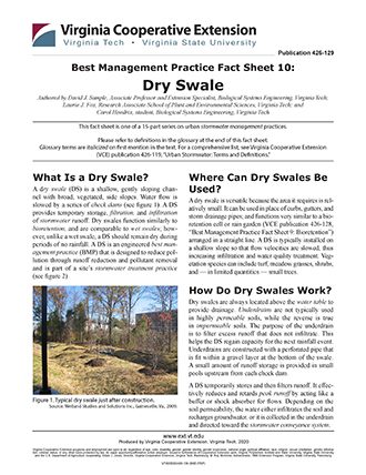
Best Management Practice Fact Sheet 10: Dry Swale

ID

426-129 (BSE-278P)

Authors as Published

Authored by David J. Sample, Associate Professor and Extension Specialist, Biological Systems Engineering, Virginia Tech; Laurie J. Fox, Research Associate School of Plant and Environmental Sciences, Virginia Tech; and Carol Hendrix, student, Biological Systems Engineering, Virginia Tech


This fact sheet is one of a 15-part series on urban stormwater management practices.

Please refer to definitions in the glossary at the end of this fact sheet. Glossary terms are italicized on first mention in the text. For a comprehensive list, see Virginia Cooperative Extension (VCE) publication 426-119, “Urban Stormwater: Terms and Definitions.”


What Is a Dry Swale?

A dry swale (DS) is a shallow, gently sloping channel with broad, vegetated, side slopes. Water flow is slowed by a series of check dams (see figure 1). A DS provides temporary storage, filtration, and infiltration of stormwater. Dry swales function similarly to bioretention, and are comparable to wet swales; however, unlike a wet swale, a DS should remain dry during periods of no rainfall. A DS is an engineered best man-agement practice (BMP) that is designed to reduce pollution through runoff reduction and pollutant removal and is part of a site’s stormwater treatment practice (see figure 2).

a photo of typical dry swale and trees
Figure 1. Typical dry swale just after construction. Source: Wetland Studies and Solutions Inc., Gainesville, Va., 2009.
Profiles and sections explaining how the dry swale consists of.
Figure 2. Profiles and sections of a typical dry swale. (VA-DCR 2011)

Where Can Dry Swales Be Used?

A dry swale is versatile because the area it requires is relatively small. It can be used in place of curbs, gutters, and storm drainage pipes; and functions very similar to a bioretention cell or rain garden (VCE publication 426-128, “Best Management Practice Fact Sheet 9: Bioretention”) arranged in a straight line. A DS is typically installed on a shallow slope so that flow velocities are slowed, thus increasing infiltration and water quality treatment. Vegetation species can include turf, meadow grasses, shrubs, and — in limited quantities — small trees. 

How Do Dry Swales Work?

Dry swales are always located above the water table to provide drainage. Underdrains are not typically used in highly permeable soils, while the reverse is true in impermeable soils. The purpose of the underdrain is to filter excess runoff that does not infiltrate. This helps the DS regain capacity for the next rainfall event. Underdrains are constructed with a perforated pipe that is fit within a gravel layer at the bottom of the swale. A small amount of runoff storage is provided in small pools upstream from each check dam. 

A DS temporarily stores and then filters runoff. It effectively reduces and retards peak runoff by acting like a buffer or shock absorber for flows. Depending on the soil permeability, the water either infiltrates the soil and recharges groundwater, or it is collected in the underdrain and directed toward the stormwater conveyance system.

Water quality improvement in a DS is provided by natural processes, including biological uptake, filtering, infiltration, and settling. Dry swales are effective at removing excess nutrients and sediment and significantly reducing runoff.

Limitations

  • Off-road parking and snow removal can destroy a DS. 
  • The drainage area leading to a DS is generally smaller than 5 acres to keep flows lower and prevent erosion. The area depends upon the slope and extent of impervious surfaces upstream of the DS.
  • The DS must be placed 2 feet or more above the water table to provide sufficient treatment before reaching groundwater. 
  • Groundwater contamination could result from DS use in commercial and industrial areas. This is due to increased infiltration into the water table and potential contaminants.
  • Soils should be highly permeable or may require a soil amendment. 
  • Underdrains are required for less permeable soils.

Maintenance 

Routine Maintenance (annual)

  • Inspect the DS and replace vegetation as needed to prevent bare ground and erosion of side slopes or channel. 
  • Remove woody vegetation like tree seedlings from the main channel.
  • Inspect to make sure the DS is functioning and clear of debris. Repair as needed. 
  • Remove trash and debris.

Nonroutine Maintenance (as needed)

  • Remove accumulated sediment above check dams.

Performance

Dry swales are effective at removing multiple pollutants from incoming water flow. A typical DS is expected to reduce total phosphorus (TP) by 52 percent and total nitrogen (TN) by 55 percent. Advanced designs pro-vide for off-line design, multiple treatment cells, and dense and diverse vegetation (i.e., not a single turf spe-cies) to enhance treatment. Advanced DS designs can improve the expected reduction of TP to 76 percent and TN to 74 percent (VA-DCR 2011).

Expected Cost

Dry swales vary in price depending on the complexity of the design. An estimate of the cost of a dry swale is approximately $16/ft3 of the surface area of the practice, approximately 1/2 the cost of bioretention (see VCE pub 426-128). This does not include the value of land dedicated to the BMP. A DS is a relatively inexpensive stormwater treatment practice when compared to other alternatives. Maintenance costs are variable and can be reduced if sediment and debris are frequently removed from the DS as a preventive maintenance practice.

Additional Information

The Virginia departments of Conservation and Rec-reation (VA-DCR) and Environmental Quality (VA-DEQ) are the two state agencies that address nonpoint source pollution. The VA-DCR oversees agricultural conservation; VA-DEQ regulates stormwater through the Virginia Stormwater Management Program. Additional information on best management practices can be found at the Virginia Stormwater BMP Clear-inghouse website at
https:// www.swbmp.vwrrc.vt.edu/ (Permanent link: https:// perma.cc/WC5L-KCZ8). The BMP Clearinghouse is jointly administered by the VA-DEQ and the Virginia Water Resources Research Center.

Online Resources

Charles River Watershed Association
https://www. crwa.org/hs-fs/hub/311892/file-634306344-pdf/ Our_Work_/Blue_Cities_Initiative/Resources/Stormwater_BMPs/CRWA_Vegetated_Swale.pdf

University of Florida Build Green –
http://buildgreen.ufl.edu/Fact_sheet_Bioswales_Vegetated_Swales.pdf

Virginia Stormwater BMP Clearinghouse –
https://www.swbmp.vwrrc.vt.edu/ (Permanent link: https://perma.cc/WC5L-KCZ8)

Companion Virginia Cooperative Extension Publications

Daniels, W., G. Evanylo, L. Fox, K. Haering, S. Hodges, R. Maguire, D. Sample, et al. 2011. Urban Nutrient Management Handbook. Edited by M. Goatley. VCE Publication 430-350.

Sample, D., et al. 2011-2012. Best Management Practices Fact Sheet Series 1-15. VCE Publications 426- 120 through 426-134.

Acknowledgements

The authors would like to express appreciation for the review and comments provided by the following individuals: Mike Andruczyk, lecturer, Virginia Tech; Lia Doumar, Undergraduate Student, Biological Systems Engineering, Virginia Tech; Paige Thacker, associate Extension agent, Virginia Cooperative Extension, Virginia Tech; and Greg Wichelns, district manager, Culpeper Soil and Water Conservation District.

References

U.S. Department of Transportation. Federal Highway Administration. 2002. Stormwater Best Management Practices in an Ultra-Urban Setting: Selection and Monitoring. FHWA-EP-00-002. https://www.environment.fhwa.dot.gov/Env_topics/water/ultraurban_bmp_rpt/5mcs2.aspx (Permanent link: https://perma.cc/EH7V-4GF7).

Virginia Department of Environmental Quality (VA DEQ). 2011. Virginia DEQ Stormwater Design Specification No.10: Dry Swales, Version 1.9. https://www.swbmp.vwrrc.vt.edu/wp-content/uploads/2017/11/BMP-Spec-No-10_DRY-SWALE_v1-9_03012011.pdf.

Glossary of Terms

Best management practice (BMP) – Any treatment practice for urban lands that reduces pollution from stormwater. A BMP can be either a physical structure or a management practice. Agricultural lands have a similar, but different, set of BMPs that are used to mitigate agricultural runoff.

Biological uptake – The process by which plants absorb nutrients for nourishment and growth.

Bioretention, bioretention cell – A BMP that is a shallow, landscaped depression that receives and treats runoff with the goal of discharging water of a quality and quantity similar to that of a forested watershed. Bioretention cells typically consist of vegetation, soils, and, optionally, an underdrain and an outlet structure. Bioretention is sometimes called a rain garden.

Check dam – A small structure, either temporary or permanent, usually made of stones or logs constructed across a ditch, swale, or channel to reduce concentrated flow velocity.

Dry swale – A shallow, gently sloping channel with broad vegetated side slopes and low velocity flows. They are always located above the water table to provide drainage capacity.

Erosion – A natural process by either physical processes such as water or wind, or chemical means that moves soil or rock deposits from one source and transports it to another. Excessive erosion is considered an environmental problem that is very difficult to reverse.

Filtration – A treatment method that removes pollutants by straining, sedimentation, and similar processes.

Groundwater contamination – The presence of unwanted chemical compounds in groundwater. In the case of infiltrative stormwater treatment, it would normally refer to dissolved compounds, such as nitrates. It could possibly include unwanted bacteria.

Impermeable – A hard surface that does not allow water to flow through it.

Impervious surface – A hard surface that does not allow infiltration of rainfall into it; not permeable.

Infiltration – The process by which water (either surface water, rainfall, or runoff) enters the soil.

Media, Media Filter Bed, Filter Bed – The topsoil that supports plant growth. Bioretention media is used in DS, and typically has a high sand and low clay content and a low phosphorus content.

Nutrients – Substances required for growth of all biological organisms. When considering water quality, the nutrients of most concern in stormwater are nitrogen and phosphorus, because they are often limiting in downstream waters. Excessive amounts of these substances are pollution and can cause algal blooms and dead zones to occur in downstream waters.

Outlet – The point of exit of water from a downspout or other BMP , usually through a control such as an outlet structure.

Peak runoff – The highest amount of water flowing off a surface during a storm event.

Permeable – A surface that water can easily flow through (porous); allows infiltration into it.

Sediment – The soil, rock, or biological material particles formed by weathering, decomposition, and erosion. In water environments, sediment is transported across a watershed via streams.

Settling – The process by which particles that are heavier than water fall to the bottom under the influence of gravity.

Stormwater – Water that originates from impervious surfaces during rain events; often associated with urban areas and also called runoff.

Stormwater conveyance system – Means by which stormwater is transported in urban areas.

Stormwater treatment practice – A type of best management practice that is structural and reduces pollution in the water that runs through it.

Underdrain – A perforated pipe in the bottom of a treatment practice, such as bioretention or permeable pavement, designed to collect water that does not infiltrate into native soils.

Watershed – A unit of land that drains to a single “pour point.” Boundaries are determined by water flowing from higher elevations to the pour point. A pour point is the point of exit from the watershed, or where the water would flow out of the watershed if it were turned on end.

Water table – The depth at which soils are fully saturated with water.

Wet swale – A shallow, gently sloping channel with broad, vegetated side slopes constructed to slow runoff flows. It typically stays wet by intercepting the shallow groundwater table.


Virginia Cooperative Extension materials are available for public use, reprint, or citation without further permission, provided the use includes credit to the author and to Virginia Cooperative Extension, Virginia Tech, and Virginia State University.

Virginia Cooperative Extension is a partnership of Virginia Tech, Virginia State University, the U.S. Department of Agriculture, and local governments. Its programs and employment are open to all, regardless of age, color, disability, sex (including pregnancy), gender, gender identity, gender expression, national origin, political affiliation, race, religion, sexual orientation, genetic information, military status, or any other basis protected by law

Publication Date

March 5, 2020