

Basic Principles of Watershed Restoration and Stormwater Management in the Chesapeake Bay Region
ID
SPES-195NP
Introduction
The objective of this document is to provide an overview of the most relevant urban stormwater management and watershed restoration issues, common mitigating practices, and regulations relevant to the Chesapeake Bay watershed. Land use and landscaping practices can drastically change how water flows on the landscape and ultimately impacts the health of our streams, rivers, and bays.
Regulatory requirements for stormwater management are beginning to include urban runoff from both pervious and impervious areas, so many of the newer, “greener” stormwater management practices may become part of the landscape of an average urban site. Thus, background knowledge in stormwater quantity and quality will be beneficial for landscape professionals. Although there are differences in practices and how stormwater is managed in the different Bay states, the basic concepts remain universal and are highlighted in this document. References to specific state requirements and programs are provided. A list of practices and guidance on designing sustainable landscapes is also included.
Background
What is an Ecosystem?
In order to understand sustainable landscaping, it is important to understand the concept of an ecosystem:
“An ecosystem is a complex set of relationships among living and non-living things. Air, water, soil, sunlight, plants and animals – including humans – make up an ecosystem. Ecosystems can be as tiny as a patch of dirt in your backyard, or as large as the entire Chesapeake Bay Watershed. The Chesapeake Bay, the largest estuary in the United States, is an extremely productive and complex ecosystem. The Bay ecosystem consists of the Bay itself, its local rivers and streams, and all the plants and animals it supports.” (Chesapeake Bay Program http://chesapeakebay.net/discover/bayecosystem).
What is a Watershed?
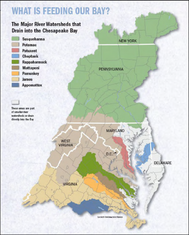
A watershed is an area of land that drains into a body of water. When precipitation falls to the ground it either moves downward through the ground to the underground aquifers or stays at the surface moving horizontally across forested, agricultural, or urban/ suburban areas as overland flow (“runoff”) before entering bodies of water like ponds, lakes, reservoirs, streams, rivers, and bays. Groundwater from aquifers also flows or discharges into natural waterbodies. Together, land and water make up a watershed system. Watersheds (or basins) can be any size, but generally the larger the body of water the larger the watershed. For example, the Chesapeake Bay Watershed covers 64,000 square miles and drains from six states and the District of Columbia. Smaller local or sub-watersheds (tributaries) drain much smaller areas that are sometimes only a few acres in size. Regardless of where someone lives they are living within a watershed. Signage along the road can sometimes be seen identifying the boundaries of different watersheds when driving. Figure 1 shows the major river watersheds that comprise the larger Chesapeake Bay watershed.
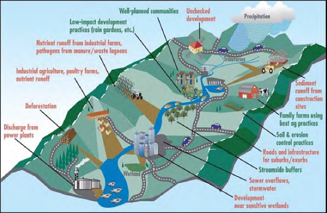
Healthy watersheds are a vital component of a healthy environment. Watersheds act as filters for runoff, providing clean water for drinking, irrigation, vegetation, aquatic life and industry. Recreation and leisure activities are important components of watersheds, with many people taking advantage of boating, fishing, and swimming in our mid-Atlantic waters. Watersheds also support a diverse variety of plant and wildlife communities. Scientists and community leaders recognize the best way to protect water resources is to understand and manage them on a watershed basis. Human activities as well as natural events that occur in a watershed can affect water quality throughout the entire system. Figure 2 illustrates a typical watershed. All upstream land uses and practices contribute to downstream water quality. The highest areas of the landscape (indicated by a white dashed line and the mountain tops in Figure 2) are the boundaries of the watershed.
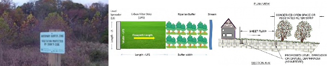
Parks, open spaces, riparian buffers, streams, and wetlands connect aquatic and forested ecosystems within the watershed. This connected natural system is also known as “green” infrastructure. In essence, environmental site planners, urban nutrient planners and sustainable landscape professionals are stewards of the green infrastructure system.
What is Stormwater?
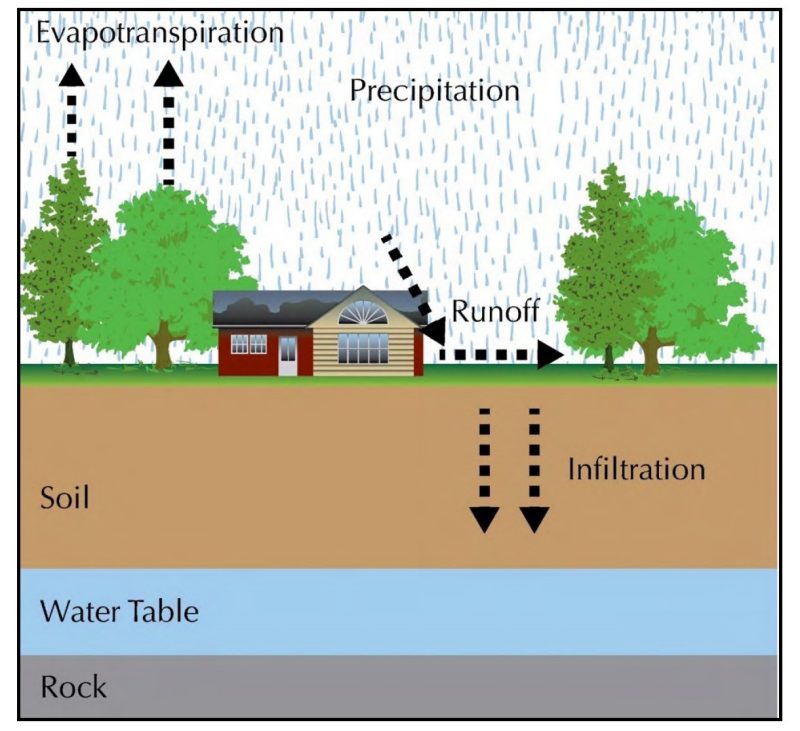
Stormwater begins as precipitation in the form of rain, snow, or ice. The movement of water from precipitation through a natural environment or ecosystem is called the hydrologic cycle. In natural environments, precipitation is slowed down, filtered, and absorbed by plants or soaked into the ground through a process called infiltration. Living vegetation takes up the water and then creates water vapor that is released to the atmosphere; this is known as evapotranspiration. Water also returns to the atmosphere through evaporation, then becomes precipitation again to complete the hydrologic cycle (Figure 3). On pervious areas, precipitation, usually in the form of rain, falls on the land and infiltration occurs until soil saturation has been reached, after which runoff will occur. Runoff from pervious surfaces may also occur in areas with steep slopes, low vegetation, and/or during high, intense rainfall events when land cover or slopes don’t allow water to slow down and infiltrate. In urban areas, impervious or hard surfaces don’t allow for infiltration and thus runoff occurs almost immediately. The terms “stormwater” and “runoff” are synonymous.
Factors that affect the volume and velocity of runoff include:
- Quantity, frequency, intensity, and duration of precipitation.
- Extent of impervious surfaces on the site (rooftops, driveways, patios and decks, roadways, parking lots, etc.).
- Type and condition of soils i.e., water infiltrates clay or compacted soils slower than sandy soils.
- Soil saturation level at the time of the precipitation. Pervious areas that would normally infiltrate can be a source of runoff if the soil is already saturated before precipitation. Soil saturation can also occur due to excessive irrigation.
- Vegetative canopy layers and coverage. Runoff is reduced on sites with a higher proportion of vegetative coverage and multiple canopy layers.
- Extent and steepness of slopes.
- Land use and land cover.
Where Does Stormwater Go?
In urban/suburban areas, water supply, wastewater, and stormwater are managed through piped systems. Potable water and sanitary sewer or wastewater systems enter and exit a building or property through separate systems. Wastewater (household water and waste from toilets, sinks, and showers) leaving a property is conveyed through pipes and typically discharged to a wastewater treatment facility or possibly a septic system. Stormwater drains from rooftops and streets and is collected through storm drains or ditches and conveyed separately from wastewater through “municipal separate storm sewer systems” or MS4s, which drain directly into receiving waters (usually smaller streams and/or lakes, wetlands, bays, estuaries, ponds or reservoirs).
Traditionally, stormwater was managed by moving it as quickly as possible away from roads and structures. Figure 4 illustrates and compares the wastewater and stormwater pathways in a typical urban “gray infrastructure” system. Wastewater from laundry, bathroom sinks, and showers is often classified as “gray water” and could be recycled; however, in most homes, this gray water is discharged to the wastewater or “black water” system (shown in purple in Figure 4). In some cases, stormwater is also classified as a gray water system.
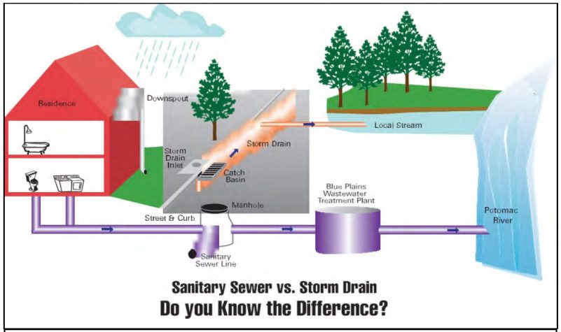
Sanitary Sewer
The sanitary sewer collects wastewater generated from the indoor plumbing (i.e. toilets, sinks, showers, washing machines, etc.) of residential, commercial and industrial properties and conveys it to a wastewater treatment plant. The City’s sanitary sewers flow to Blue Plains Wastewater Treatment Plant, where nutrients, sediment and pollution is removed from the water before being discharged into the Potomac River.
Storm Drain
The storm drain is a system of inlets, pipes and swales that drain excess rain and ground water from impervious surfaces (paved streets, parking lots, sidewalks, roofs) to prevent or minimize flooding. The stormwater runoff collected by the storm drain is discharged to local streams untreated. The water then flows to the Potomac River and eventually to the Chesapeake Bay.
Many people believe that stormwater flows through storm drains to a treatment facility. This is true only in some older urban areas where both stormwater and wastewater flow through a “combined sewer system” to a treatment facility. A major problem of a combined sewer system is overflow of untreated or partially treated wastewater that occurs when runoff volume exceeds the conveyance and storage capacity of the system (e.g., during a heavy rain). This is known as a “combined sewer overflow,” (CSO) and is one source of water pollution in urban areas. In most, modern systems, storm sewers and sanitary sewers are managed separately.
In many urban, suburban, and rural areas, stormwater on and between properties was traditionally conveyed away from buildings through grading and drainage swales. Sites are graded so that runoff flows over the land surface and discharges either directly into a waterbody or flows into drainage swales and roadside ditches which also discharge directly into a local waterbody or stormwater pond.
Stormwater Quantity and Quality Issues
As natural areas and undeveloped land are cleared for human use and development (urbanization), the systems that filter and absorb runoff (such as forests, wetlands, and soils) within the watershed are replaced by rooftops, roadways and other grey infrastructure such as lawns, compacted soils, and new sources of pollution (see Figure 2).
In general, water runs off developed surfaces in higher volumes, at higher speeds, and carries with it a wider variety of pollutants than from undisturbed landscapes. Anything on the land surface such as automobile fluids, litter, leaves, debris, sediment, fertilizers, pesticides, or animal feces is swept away by the runoff and carried directly into a waterway, often through storm drains and outfalls (the point where the storm drain pipe meets the receiving water). Combined sewer overflows and other untreated discharges to a waterway are additional urban sources of pollutants. Excess nitrogen and phosphorus from fertilizers and sediment from eroded stream banks and exposed soils, can have negative effects on the health and quality of water bodies. These pollutants can cause algal blooms, block sunlight, and decrease dissolved oxygen, all conditions which can kill aquatic plants and organisms. The Chesapeake Bay and its connected waterbodies have large hypoxic dead zones, void of oxygen and life due to pollutant overload.
Urbanization and development impact land and water in several ways:
- During clearing and site preparation: vegetation is stripped away leaving exposed soils that easily erode during rainfall events, causing an increase in sediment runoff into the water downstream. Erosion and Sediment Control (ESC) practices and products are used at this stage of development to reduce the amount of erosion occurring and the amount of sediment leaving the site.
- Through construction and development: impervious surfaces are created (roofs and paved surfaces), soil is compacted, infiltration is reduced and runoff is increased. During storm events, pollutants wash off developed surfaces and are carried with runoff, which is the primary transport mechanism for pollutants such as sediment and nutrients. Pollutant loads will increase as the volume of runoff increases if prevention measures are not in place. Stormwater Best Management Practices (BMPs) are used at this stage of development to offset increases in runoff and provide treatment for pollutants.
Stormwater Quantity Issues
Figure 5 illustrates one of the most fundamental concepts in urban stormwater — a hydrograph — which is a plot of stream discharge over time during a rainfall event. When comparing the pre-development and post-development hydrographs of a stream, and comparing the presence and absence of stormwater controls (BMPs), multiple impacts from urban development are observed:
- The amount or volume of runoff that flows into a stream increases as a result of urban development.
- Runoff reaches the stream more rapidly with urban development because it flows across hard surfaces and through pipes instead of being slowed down by going over and through vegetation first.
The blue line in Figure 5 shows a typical hydrograph from undisturbed land (pre-development). After development, a typical urban hydrograph resembles the red hashed line. Note that in comparison, the red line exhibits a larger peak that occurs sooner in time. This is because traditional stormwater management for developed land functions by directing runoff into a system of drainage ditches and stormwater sewer pipes, which either discharge directly into local waterways or into a containment or pond area that stores the runoff and slowly releases water at the pre-development rate of discharge. The volume of water entering (discharging to) local waterways from the pipes and ponds is greater and more focused than that from undisturbed land. The increased runoff volume and focused nature of the discharge causes erosion and increased transport capacity for pollutants. To counteract the impacts of urbanization on streams, stormwater management now seeks to reduce runoff and replicate pre-development conditions (green dotted line) by installing practices that increase infiltration on site instead of storing the stormwater somewhere else. These practices are sometimes called “environmental site design” or “low impact development” or “green infrastructure.”
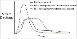
After the storm event has passed and the hydrograph returns to normal, the level of water in the stream is lower than what would be found under natural conditions. Without infiltration, groundwater recharge is reduced and water tables are lowered, often below the bottom of the streambed. Thus, groundwater flow into the stream has been reduced. The result is less or no groundwater inflow into a stream.
Figure 6 illustrates the net impact of these changes across an annual hydrologic cycle. The horizontal portion shows the continuum of urbanization from left to right, with natural ground cover on the left, moving through suburban, then urban development, to 75 to 100 percent imperviousness on the right. The top part of the figure shows the changes in evapotranspiration (ET), runoff, infiltration, and groundwater recharge (deep infiltration) as impervious area increases. Evapotranspiration decreases because there is less vegetation. Runoff significantly increases because water can’t infiltrate. If stormwater can’t infiltrate, then groundwater isn’t recharged.
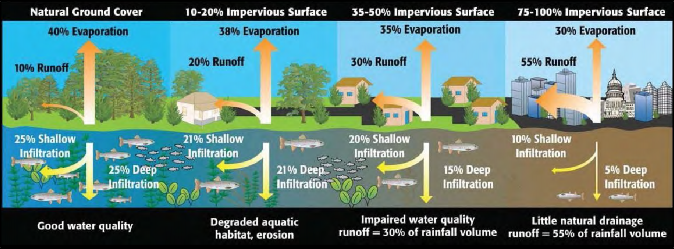
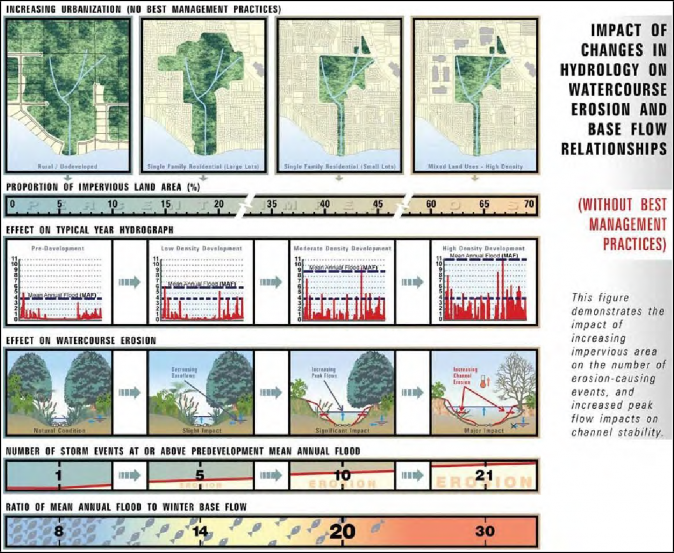
Figure 7 illustrates the subsequent geomorphic effects of urbanization on a receiving stream. A continuum of urbanization is shown from left to right. As development increases, significant changes occur. Runoff peak flows and frequencies increase. This results in increased erosion of the stream channel. It widens and deepens to accommodate the volume and velocity of stormwater. Also, urban streams tend to dry out due to the lack of groundwater recharge resulting in a loss of stream length. The urban stream widens, deepens, and dries out, seriously impacting or destroying aquatic ecosystems and associated green infrastructure.
The relationship between impervious surfaces, watershed health, and stream ecology is the basis of the Impervious Cover (or surface) Model first proposed by Tom Schueler in 1994 (Chesapeake Stormwater Network, http://chesapeakestormwater.net/2009/11/ the-reformulated-impervious-cover-model/). In the Chesapeake Region, site design, erosion and sediment control, and stormwater management regulations and practices are required to reduce and control runoff to minimize the impacts of urbanization on watershed health, stream channels, and stream ecology.
Stormwater Quality Issues
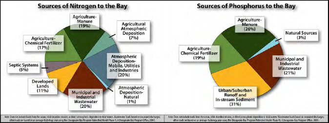
Untreated and uncontrolled stormwater from developed lands results in higher stream flows with increased stream erosion and higher concentrations (loads) of sediment, nutrients (nitrogen and phosphorus), and other pollutants in downstream receiving waters and eventually the Chesapeake Bay. This can degrade water quality and impact watershed health. When receiving waters deteriorate to the point of not meeting their designated use, they are listed as “impaired.” Typical designated uses in Chesapeake Bay tidal areas include: migratory fish spawning and nursery, shallow-water, open-water fish and shellfish, deep-water seasonal fish and shellfish, and deep channel seasonal refuge. Typical designated uses in non-tidal areas may include fish consumption, recreation, water supply, and aquatic life. Additional designated uses and use classes are determined by each state. Once a stream is classified as impaired for one or more of these designated uses, several steps are taken by the federal and state regulatory agencies to comply with the Clean Water Act. A Watershed Implementation Plan is developed that helps guide restoration activities within the watershed. Necessary actions could include implementing green infrastructure to reduce stormwater impacts, new development rules that protect natural spaces, upgrades to wastewater treatment plants, or improvements on agricultural land. This impacts everyone locally as well as the water bodies that are downstream. Nitrogen, phosphorus, and sediment are the primary pollutants of concern in the Chesapeake Bay watershed. Figure 8 depicts the proportional nitrogen and phosphorus loadings, respectively, from different land uses in the Chesapeake region.
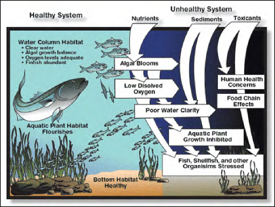
Once a rich and productive estuary, the health of the Chesapeake Bay has declined due in large part to pollution carried by stormwater runoff and generated from urban and industrial development and agricultural practices throughout the watershed. Within the bay and its tributaries, sediment, nutrients, toxic chemicals, and other pollutants cause a variety of problems such as excess algae growth, reduced dissolved oxygen levels, and decreased water clarity. This process is illustrated in Figure 9.
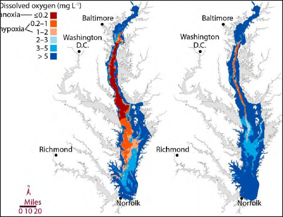
Once the algae consume all the nutrients, the algae die and use up the oxygen in the water through decomposition, causing large anoxic or dead zones to develop (Figure 10). This causes stress to the aquatic ecosystem. Sediment clouds the water, reducing clarity and coating the underwater vegetation. Light cannot get through.
The plants cannot photosynthesize and begin dying off. Without plants, the fish, shellfish and other organisms become stressed and eventually move out of the area or die. Unhealthy waterways mean a reduction in the fish and shellfish that support the livelihoods of local watermen and supply local restaurants. It also means that water becomes less desirable for recreation that in turn threatens local economies that depend on tourism. Public health, drinking water costs, and property values are also negatively affected by poor water quality.
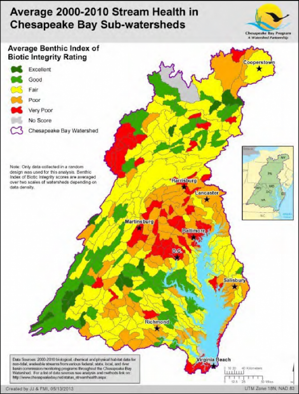
A key means of assessing stream health is evaluating the diversity, number, and health of benthic macro-invertebrates. These small organisms serve as an indicator of conditions in the stream and the upstream watershed, similar to a canary in a coal mine. In the Chesapeake Bay region, periodic measurements are made of stream health, and are mapped by watershed (Figure 11). Those that are unhealthy and unable to support a healthy aquatic ecosystem are shown in red while healthy, productive streams are shown in green. The majority of the streams and watersheds in the Bay watershed are considered impaired.
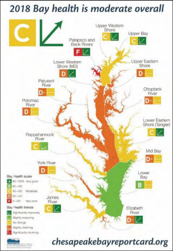
Efforts to improve the water quality in streams, rivers, and the Chesapeake Bay are ongoing through numerous organizations and agencies. The overall health of the Bay is assessed each year, and the results are published as part of the “Bay Report Card.” A recent assessment of water quality and ecosystem health of the bay estuary is provided in Figure 12. Urban Stormwater is the only sector that is increasing in nitrogen and phosphorous inputs, which is why it has received regulatory attention. Thus, stormwater management in the landscape needs to focus on reducing pollution that runs off urban areas to receiving waters and the Chesapeake Bay. Regulation is described in the next section.
Managing Urban Stormwater
At the National and Regional Level
The federal Clean Water Act (CWA), created in 1972, regulates discharges of pollutants into water bodies of the U.S. and provides for the establishment of water quality standards. To achieve the goal of clean and healthy waters that support aquatic life and recreation, the CWA created programs designed to regulate and reduce the amount of pollution entering United States waters. One such program is Section 303(d) of the CWA, which requires states to assess their waterbodies to identify those not meeting water quality standards. If a waterbody is not meeting standards, it is listed as impaired and reported to the U.S. Environmental Protection Agency (EPA). The state then develops a plan to clean up the impaired waterbody. This plan includes the development of a Total Maximum Daily Load (TMDL) for the pollutant(s) that were found to be the cause of the water quality violations. A TMDL calculates the maximum amount of a specific pollutant that a waterbody can receive and still meet water quality standards. It also establishes a pollutant budget or “diet,” which allocates portions of the overall pollution load to the pollutant’s various sources. Just as a person can only eat a certain amount of calories in one day without harming their health, a waterbody can only absorb so much of a pollutant without harming its health. More than 40,000 TMDLs are in place across the country for different watersheds.
In 2010, the EPA finalized the Chesapeake Bay TMDL that provides guidelines for restoring the health of the Bay’s waters by defining pollution reduction goals or “pollution diets” for nitrogen, phosphorus, and sediment by 2025. The Bay TMDL is unique in that it requires jurisdictions within the Bay watershed to develop Watershed Implementation Plans (WIPs) that propose the allocation of nitrogen, phosphorus, and sediment loads to sources or sectors (e.g. agriculture, municipal wastewater systems, septic systems, and urban stormwater). The WIPs must also describe the management steps jurisdictions intend to take to meet water quality standards. The WIPs developed by the states and approved by EPA provide a roadmap for how and when each jurisdiction intends to meet its pollutant allocations under the Bay TMDL. Each jurisdiction has been working with local governments to implement those WIPs and achieve 60% of their TMDL goals by 2017 and 100% of the goals by 2025. An approximate assessment of the overall reductions in nitrogen, phosphorus, and sediment loadings needed to meet the 2025 goals is provided in Figure 13. For instance, the James River watershed will need to meet reductions of 26% for nitrogen, 27% for phosphorus, and 27% for sediment. It will require a significant, multi-sector effort to meet these reductions.
The Chesapeake Bay Program (CBP) was established in 1983 as a regional partnership of federal and state agencies, local governments, non-profit organizations, and academic institutions that leads and directs Chesapeake Bay restoration and protection. In 2014, members of the CBP signed the Chesapeake Bay Watershed Agreement that established “goals and outcomes for restoration of the Chesapeake Bay, its tributaries and the land that surrounds them” (CBP http://www.chesapeakebay.net/chesapeakebaywatershedagreement/page).
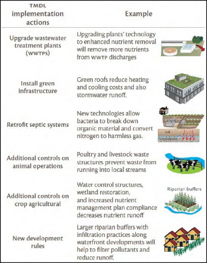
Implementable actions that local, state, and federal governments can take to meet Chesapeake Bay TMDL goals are shown in Figure 14. Best management practices (BMPs) for the Chesapeake Bay region are approved by various technical, multi-stakeholder workgroups. The Urban Stormwater Workgroup recommendations, approved practices, and updates are posted on the Chesapeake Stormwater Network website at http://chesapeakestormwater.net/bay-stormwater/urban-stormwater-workgroup/.
Point sources of pollution: single, identifiable outputs of pollution to a waterbody. They may be publicly owned wastewater treatment works, privately owned treatment facilities, industrial discharges, and sometimes, large agricultural operations. (Modified from 40 CFR Ch. 1 Part D, Section 122.2)
Nonpoint sources of pollution: polluted runoff primarily from urban, suburban, and developing areas and some agriculture sites. The numerous and diffuse nature of nonpoint sources make them difficult to regulate. Under the CWA, pollution from urban runoff is now more strictly regulated through permits for municipal separate storm sewer systems (MS4s) and construction projects. Other nonpoint source pollution problems have also been addressed through a variety of incentive programs. (https://oceanservice.noaa.gov/education/kits/pollution/02history.html)

At the State Level
At the state or jurisdiction level, state agencies manage and regulate water quality and stormwater programs through WIPs, TMDL action plans, permits from the National Pollutant Discharge Elimination System (NPDES), construction permits, and other environmental programs and strategies. Each state has established a list of approved actions, practices, guidance manuals, and minimum design standards to meet water quality goals. In general, most stormwater programs have shifted away from a conveyance, storage, and treatment approach toward a site design and stormwater management approach that prioritizes runoff reduction. Table 1 is a summary of resources and links developed by the Chesapeake Stormwater Network for each Chesapeake Bay jurisdiction.
At the Local Level
Local governments are responsible for overseeing and complying with state and federal water quality and stormwater regulations and permits. Each local government has ordinances and permit requirements that dictate how land can be developed, used, and maintained. Many local government stormwater and water quality programs require the use of a combined site and stormwater design process known as the runoff reduction method (RRM) to ensure that pre-development runoff volume is maintained for new development (or exceeded in the case of redevelopment projects) and water quality goals are met as land is developed. In addition to state level requirements, some counties, municipalities, or non-governmental organizations (NGOs) have developed watershed action plans for their specific regions either as part of or separate from a TMDL or MS4 permit. Urban localities plan and implement public green infrastructure projects like “green streets” and other stormwater retrofits for public and private properties to reduce and manage runoff from existing development that is currently untreated or inadequately treated by an existing stormwater system.
“Green infrastructure uses vegetation, soils, and natural processes to manage water and create healthier urban environments. At the scale of a city or county, green infrastructure refers to the patchwork of natural areas that provide habitat, flood protection, cleaner air, and cleaner water. At the scale of a neighborhood or site, green infrastructure refers to stormwater management systems that mimic nature by soaking up and storing water.” Source: http://water.epa.gov/infrastructure/greeninfrastructure/gi_what.cfm
Local government, watershed groups and soil and water conservation districts may have cost-share programs to encourage the installation and maintenance of retrofits of residential, small commercial, and institutional properties to meet water quality goals and increase watershed stewardship. Check with local agencies or groups to see if any sites have been identified for such future projects. There may be an opportunity to leverage resources or share workload with local partners to design, install, and maintain these projects.
Before beginning work on a site, be aware that stormwater practice design standards and terms vary depending on state/region/locality. In addition, some commonly used BMPs approved by the Chesapeake Bay Program may not be appropriate because of karst (topography with sinkholes or caves) or high water-table conditions. Consult with local jurisdictions or national program websites to learn about the specific terminology, definitions, and practices used in specific regions. Be sure to check the local codes and ordinances where a project is being installed.
“Stormwater retrofits are a diverse group of projects that provide nutrient and sediment reduction from existing development that is currently untreated or is inadequately treated by an existing stormwater practice.” Source: CSN Good Recipes for the Bay Pollution Diet U-1 Urban Stormwater Retrofits
At the Site Level
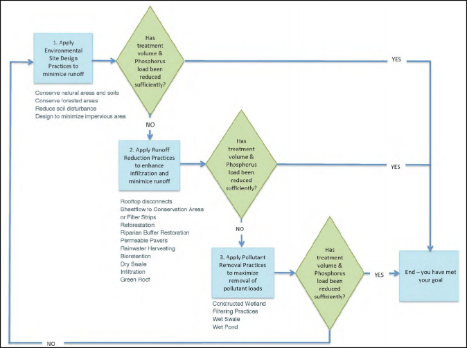
Until recently, stormwater management at the site level focused exclusively on management of impervious areas and the use of stormwater treatment ponds. As our understanding of the impacts of impervious surfaces and non-point source pollution from urban areas has improved, stormwater management and site design has evolved and shifted toward managing runoff from both impervious and pervious urban areas at the watershed, development parcel, and single-lot scales with the increase of the RRM process. RRM is a multi-step, iterative site and stormwater management design process that employs environmental site design (ESD) techniques to minimize the generation of runoff; promotes the use of runoff reduction (RR) stormwater practices that infiltrate, re-use and treat runoff; and utilizes pollutant removal or stormwater treatment (ST) practices to treat remaining loads (see Figure 15).
Environmental Site Design (ESD): A comprehensive design strategy for maintaining predevelopment runoff characteristics and protecting natural resources. Relies on integrating site design, natural hydrology, and smaller stormwater practices to control, capture and treat runoff. (Ch. 5.0 Environmental Site Design, Maryland Department of the Environment)
Runoff reduction (RR)
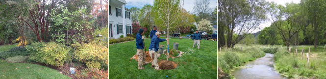
These practices reduce and treat runoff volume through infiltration, vegetation, absorption in media, storage and reuse. Site design or landscape restoration (non-structural) RR practices include rooftop/impervious surface disconnection, soil restoration and/or amendments, sheet flow through vegetated filter strips or conserved natural vegetation, reforestation, urban tree planting, buffer plantings, and replacing impervious surfaces or turf with conservation landscaping using native plants. Bioretention, dry swales, permeable hardscapes, green roofs, and cisterns are all forms of structural or constructed runoff reduction type stormwater BMPs used for new construction, redevelopment and stormwater retrofits. (Sample, David & Fox, Laurie.)
Stormwater Treatment (ST)
These practices reduce pollution through physical means such as settling or filtering through media. Wetlands, sand filters, wet swales, and wet ponds are examples of this type of BMP. (Sample, David & Fox, Laurie.)
The RRM incorporates a spreadsheet-based methodology that estimates runoff volumes and pollutant loads associated with development, and the nutrient and sediment reductions provided by implementation of BMPs (Hirschman, 2008).
ESD techniques reduce runoff by minimizing site disturbance and impervious surface area while maximizing conservation practices and distributed small-scale stormwater RR practices. The techniques are integrated into the site and stormwater plans for new development or redevelopment projects through regulatory, land-use, and construction permitting processes or are integrated with grey infrastructure systems and into the landscape through landscape restoration or retrofitting existing properties.
Low impact development (LID), cluster development, conservation subdivisions, Better Site Design (BSD), Green Area Ratio (GAR), Leadership in Energy and Environmental Design (LEED), Sustainable SITES, and Living Building Challenge also use an ESD approach for new development and redevelopment sites. Cluster development or conservation subdivisions cluster buildings and maintain connectivity of green infrastructure to provide open space and protect natural resources and critical habitats. The net impact of all environmental site design techniques from a stormwater perspective is that impervious surfaces, urban runoff, and downstream impacts are minimized through the site design process.
Low Impact Development (LID): An innovative stormwater management approach with a basic principle that is modeled after nature. It requires managing rainfall at the source using uniformly distributed, decentralized micro-scale green infrastructure or LID stormwater practices. The goal is to mimic a site’s predevelopment hydrology by using design and stormwater management techniques that infiltrate, filter, store, evaporate, and detain runoff close to its source.
(LID Center, http://www.lid-stormwater.net/background.htm)
Green Area Ratio (GAR): specific to development projects in the District of Columbia, the GAR establishes planting ratio guidelines and requires submittal of a planting plan by a qualified landscape professional. https://doee.dc.gov/service/green-area-ratio-overview.
Whether used for new construction, redevelopment, or a sustainable landscape restoration and retrofit of an existing property, ESD methods critically assess a property and design to preserve existing features of value and incorporate new features to enhance the natural processes and ecosystems of the site. ESD methods are specifically designed to:
- Preserve, protect, expand, enhance, or restore existing valuable environmental features (e.g., forests, large or especially ecologically or aesthetically valuable individual trees, waterfront buffers, highly erodible soils, nesting areas, high water tables, waterways and wetlands, meadows, animal communities, areas of undisturbed native soils, rock formations, groundwater recharge)
- Minimize site grading and compaction of soils.
- Enhance connection to adjoining natural areas.
- Minimize impervious surfaces (e.g., pavement, concrete channels, roofs).
- Slow down runoff to mimic natural runoff rate and duration by infiltrating, storing, evaporating, and/or detaining runoff close to the source.
- Minimize turf and lawn areas and include native plants, materials, or features that minimize the need for fertilizers and support biodiversity and wildlife.
Once this is accomplished through site design, the next step in the iterative RRM is to select RR practices for runoff volume reduction and treatment. The final step is to incorporate the use of ST practices (if needed) to ensure that the combined site design and stormwater practices will meet the treatment volume and pollution reduction goals.
For developed or urbanized areas where runoff is untreated or inadequately treated, stormwater retrofits are incorporated into the landscape and streetscape as new green infrastructure, LID practices, or through conversion of an old storage-type practice, like stormwater ponds, to better performing infiltration practices, like constructed wetlands. Practices implemented through a government agency to retrofit an existing stormwater system for an MS4 permit or to address combined sewer overflows (CSOs) are typically designed and implemented by the locality or specialized contractors through a regulatory and permitting process.
A select group of small-scale and on-lot practices, known as residential stewardship practices (rain gardens, impervious cover removal, rainwater harvesting, downspout redirection, pervious hardscapes, urban nutrient management, tree planting) are approved by the CBP for nutrient reduction credit on residential, small commercial, and small institutional properties if properly designed, installed and maintained by the property owner, a local non-profit, or a landscape professional. Design and implementation of these residential stewardship practices may be promoted and overseen by local governments or watershed groups. These practices may require permits based on the individual site and practice type, the presence of environmentally sensitive and protected features, and the amount of disturbance required to implement the practice. Local jurisdictions and watershed groups can help determine which practices are suitable on which sites and if any special design criteria may be required locally. Some jurisdictions promote and/or financially incentivize the installation and maintenance of select BMPs. Ensure that the local jurisdiction is aware of the design and installation of stormwater BMPs so credit can be given toward meeting state and federal pollution reduction goals.
Stormwater Best Management Practices (BMPs)
The type of project (new development, redevelopment, retrofit), the intended use, state and local stormwater regulations, and site-specific characteristics identified through a detailed site assessment and RRM analysis will dictate which stormwater practices are best for each project. Each state has approved BMPs for new construction and redevelopment projects. The Chesapeake Bay Program has approved certain post-construction BMPs as stormwater retrofits and established minimum standards and protocols that must be followed for localities to get nutrient and sediment reduction credits toward the Chesapeake Bay TMDL (Bahr et al, 2012).
Details and images for each practice approved by the Chesapeake Bay Program for use in the Chesapeake Bay region are provided in Tables 2 and 3. Table 2 includes a brief description, performance data, and the type of practice. Table 3 includes construction diagrams and photographs of each practice. The BMPs listed and diagrams provided in these tables are compiled from several sources available for public use, including the Virginia Stormwater BMP Clearinghouse website (VDEQ 2013) and the Chesapeake Stormwater Network.
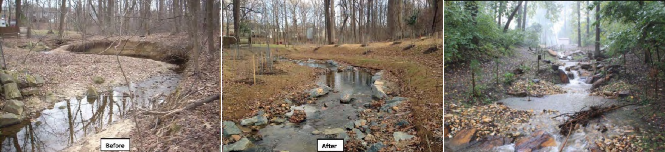
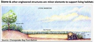
In addition to ESD, RR and ST, other downstream restoration (DR) practices can be installed to “fix” problems caused by high runoff volume and pollutant loads. A number of private companies have also developed proprietary BMPs. When stormwater is not controlled on site, stream banks and shorelines can become damaged by the increased flow of water moving through the system. To minimize the impact or to reverse the damage, DR practices such as stream restoration or living shorelines can be used. It is important to install stormwater management practices including riparian buffers upland as well, to ensure that these downstream restoration practices have a chance to succeed. Stream restoration is the practice of creating a stable stream system using structures that divert the flow to the center of the stream while protecting the banks from highly erosive forces. Often this can mean reconnecting the stream to its floodplain so that energy is dissipated across a larger area. A riparian buffer should be planted along the stream edge to reinforce the engineered project and to provide other ecological benefits. In low energy areas, living shorelines and shoreline buffers can be established by planting vegetation along tidal edges to help minimize erosion. Hybrid forms of living shorelines incorporate the use of bioengineering materials (e.g. rock or oyster sills or breakwaters) to help absorb the erosive forces of waves and protect the soil and vegetation.
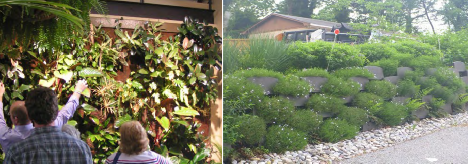
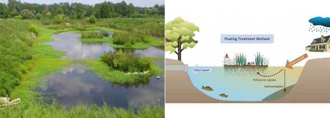
Proprietary BMP systems are developed by specific manufacturers and utilize a variety of treatment technologies to remove pollutants from urban runoff. Tree boxes, filter systems, floating wetlands, and living walls are forms of proprietary BMPs used in the Chesapeake Bay Region. Proprietary BMPs should be examined individually because limited unbiased information is available.
Associated BMP Design Terminology
Pre-development hydrology: refers to the way in which a naturally-vegetated area handles precipitation, and is an important goal for sustainable and environmentally thoughtful design. (Source: deeproot.com blog post “Maintaining Pre- Development Hydrology,” Sept. 19, 2011)
Physical properties of soil: texture, structure, permeability, porosity
Design storm: A rainfall event of specified size and return frequency (e.g., a storm that occurs only once every 2 years) that is used to calculate the runoff volume and peak discharge rate to a BMP. (Schueler, 1992)
Stormwater detention: a structure designed to manage and store excess runoff on a developed site, often in an urban setting.
Runoff volume: volume of rainfall that flows off pervious and impervious areas of a site for a design storm event.
Runoff reduction or treatment volume: total annual runoff volume reduced through canopy interception, soil infiltration, evaporation, rainfall harvesting, engineered infiltration, extended filtration or evapo-transpiration. (Chesapeake Stormwater Network, 2012)
Contributing drainage area: all stormwater practices are designed to receive, store, or treat runoff from a discrete area of land or a rooftop known as the Contributing Drainage Area. The volume of water that a practice manages is calculated from the amount of runoff generated by a design storm from the contributing drainage area.
Site Assessment/Design Process
As stormwater programs have shifted toward management of both pervious and impervious urban areas, assessing site landscaping practices and their potential impact on downstream water quality provides useful information for the landscape professional. This assessment applies the knowledge of the previous sections but it is presented at the single lot scale and from a practical perspective. Addressing the following questions and issues can provide insight on how the site will perform. Adapted from Shelton and Feehan (2008) and Anne Arundel County (2016).
Where Does Stormwater Go?
Sustainable landscapes use environmental site design and green infrastructure/LID-type stormwater BMPs to work with nature and the unique characteristics of a site. When working on a stormwater retrofit and landscape restoration plan for a site, it is important to look holistically at how the site was originally designed, how it functions, and how stormwater management can be integrated into the design and goals of the site while also keeping other environmental benefits of the site intact.
Therefore, a site assessment is the critical first step in site planning. It guides the selection of practices used on the site and informs the property owner who uses and maintains that site. The following are steps for assessing a residential, small commercial, or small institutional property to create a site plan that will guide design decisions and practice selection:
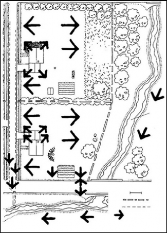
- Measure lot boundaries and buildings or obtain a copy of a recent survey of the site. An example of a simple site plan without topography is provided in Figure 16.
- Include topographical information if it is available, but a visual survey of the high and low spots on the site can suffice. The home or property owner can also provide information about where water flows and pools during heavy rain events.
- Identify impervious areas such as buildings, parking areas, sidewalks, patios, pools, decks, and driveways and how they drain (or if a drain is present).
- Show areas of steep slopes.
- Identify soil types based on soil test information, local soil maps, or Web Soil Survey.
- Conduct soil infiltration tests to determine the rate of infiltration at potential project sites.
- Mark and characterize landscaped and vegetated areas.
- Identify sensitive areas such as creeks, ditches, lakes, wetlands, storm drains, buffers, etc. Usually these would receive runoff from the site.
- Mark runoff paths and flow directions.
- Identify where the runoff leaves the site to adjacent receiving waters, storm drains, and neighboring sites.
- Talk with property owner(s) to determine their preferences for how the property is used, areas of recreation, frequently traveled pathways, aesthetics, their interest and ability to conduct the required maintenance, etc.
- Contact your soil and water conservation districts, municipal or county planning, environmental or public works department, or state environmental agency for guidance (see Figure 17).
- Check with local erosion and sediment control or planning agencies to determine permitting requirements for soil disturbance, wetlands, Resource Protection or Critical Area, protected species, and buffers.
- Call the local utility locator (e.g., MISS UTILITY, PA One Call) to have underground utilities marked. Avoid digging in these areas.
Can the Landscape Layout Be Designed or Re-Designed to Reduce Runoff?
Reference the site analysis. Minimize disturbance to natural features and incorporate sustainable landscape restoration practices such as restoring compacted soils, urban tree planting, reforestation, buffer restoration, or conservation landscaping beds of native plants instead of turf or impervious surfaces. Determine if there are problem areas where the runoff is too concentrated (i.e., many arrows coming together). And incorporate practices that slow down, spread out, and soak in the runoff. It is always a good practice to reduce runoff, especially if your runoff is ending up on neighboring sites.
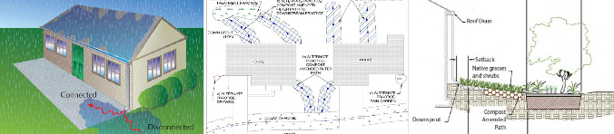
Does Roof Water Flow to Pavement or Landscaped Areas?
The impact of an impervious roof on the drainage of a site cannot be overstated. When runoff from roofs via gutters and downspouts directly flows onto pavement, runoff peak flows increase as does the potential for downstream degradation.
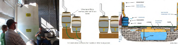
- Redirect downspouts and drain them onto a vegetated area or into a rain barrel or rain garden. A rain barrel or cistern can provide a supplemental irrigation source during dry periods.
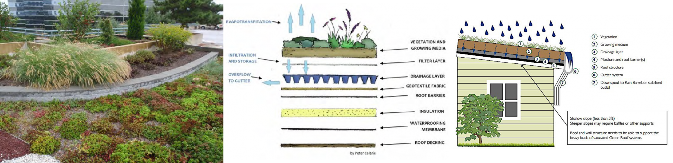
- Install a green roof. Most buildings cannot be retrofitted for a green roof without structural improvements, so this practice applies mainly to additions or new buildings.
Can Paved Surfaces Be Reduced?
On most sites, the controllable impervious areas include sidewalks, porches, patios, decks, and driveways.
- Reduce the total square footage of the impervious area and replace with a pervious surface.
- Consider a driveway that uses pavement for the tire tracks only, with turf or gravel in between.
- Use permeable hardscapes and/or paver systems. There are many new products available that allow water infiltration directly through the pavement or through joints. Remember these systems must be vacuumed to keep pore spaces from clogging and often require the involvement of a certified and trained paving professional for installation.
- Consider using stepping-stones or mulched or vegetated paths or walks. Some groundcovers can tolerate foot traffic.
- Use wider seams or joints on decks and patios for better water infiltration.
- If paved surfaces can’t be reduced, consider directing runoff from these areas to a filter strip, a conservation landscape area of native plants or grass, or into a rain garden or swale planted with native vegetation. On older commercial or small institutional properties, runoff from parking areas is often untreated. This provides opportunities for sustainable landscape restoration and small-scale stormwater retrofits.
Construction Considerations
Before initiating construction on any site, ensure the project is in compliance with all permitting and plan review requirements. Unlike conventional landscaping, sustainable landscape and BMP practice construction must be conducted in an environmentally sensitive way to protect natural resources before and during construction and to eliminate common causes of stormwater practice failure caused by soil compaction or sedimentation during the practice installation.
- Protect existing vegetation, wetlands, buffers, soils, habitat, and water resources during construction.
- Prevent contamination or damage during construction. Keep equipment in good working order and clean up any spills or leaks. Minimize equipment in the BMP to avoid damage or compaction.
- During landscape or BMP construction ensure that the installation team is trained in site protection measures including erosion control practices.
- Clearly designate protected areas, enforce compliance within those areas, and inspect protection measures during construction.
- Refer to the tree protection plan and perform any required “root pruning,” pruning of canopy, or other preservation measures specified in the plan.
- Remove only the trees or other vegetation slated to be removed.
- Maintain required depth of mulch over tree roots, and provide supplemental water in accordance with preservation measures.
- Use appropriate construction machinery - lightest, least destructive (tires versus tracks) equipment possible during site or BMP construction.
- If topsoil must be disturbed, stockpile and reuse on site.
- Provide temporary protection on site just after construction.
It is vital that stormwater practices be maintained in working order so they function as intended, providing protection and stormwater management for our homes, neighborhoods, parks, schools, and businesses. All practices must have a long-term maintenance plan in place at the end of the installation. A good reference for this is Sustainable Landscape Maintenance for the Chesapeake Bay Watershed by Cheryl Corson, found here: https://cblpro.org/downloads/CBLPMaintenanceManual.pdf.
Landscape Site Management for Source Control of Runoff
There are many practices that can be used by the sustainable landscape professional to reduce pollutants in runoff through reducing or controlling the source. Urban Nutrient Management techniques and fertilizer limitations as well as erosion and sediment control are source control methods. The following guidance is designed to assist in assessing the need for source control methods and the relative risk of a site for urban water quality issues from erosion and other pollutants.
Cover Bare Soil
Soil left exposed without vegetative cover easily erodes. When erosion occurs, sediment is transported downstream through runoff. Excess sediment clogs storm drains and reduces channel conveyance capacity, causing flooding. It also buries and destroys downstream underwater habitats, depriving fish of their food sources and living areas. These issues can be easily avoided.
- Overseed bare spots in turf or plant bare areas in beds. Aeration may be necessary on compacted areas.
- Use native ground covers if turf will not grow or is not desired.
- Use mulch if vegetation will not grow or is not desired.
- Vegetative buffers can be used along sloped or downhill portions of the site.
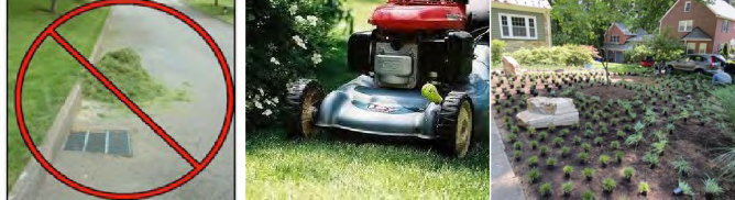
Minimize Yard and Garden Wastes
Disposing of leaves, grass clippings, branches, and other yard debris in ditches and storm drains is a common practice that clogs drainage systems, causes flooding, increases organic loading downstream, and in some cases violates local ordinances. Most urban runoff is discharged untreated to receiving waters. As the organic matter from yard debris decomposes in streams, lakes, and estuaries, it depletes oxygen in the water and can cause fish kills. Nutrients from the organic matter also cause algal blooms and aquatic weed growth which lead to an imbalance in the ecosystem. To avoid these problems:
- Sweep/collect yard debris off streets, sidewalks, and driveways.
- Dispose of debris in a compost pile or through a curbside pickup service.
- Use a mulching mower to recycle grass clippings and nutrients to the lawn.
- Use compost instead of fertilizer.
Use Integrated Pest Management Techniques to Minimize the Need for Pesticides and Handle Pesticides Safely
A wide variety of pesticides are available for use in landscapes; however, a sustainable landscape professional avoids or minimizes the use of pesticides through Integrated Pest Management (IPM). Many state Extension agencies provide IPM guidance and training and additional information.
“IPM is a natural systems approach, using the least harmful methods of managing all types of landscape pests including insects, weeds, plant pathogens or vertebrates. IPM refers to protecting biodiversity and habitat by minimizing the use of pesticides”. (Source: Cheryl Corson, Sustainable Landscape Maintenance for the Chesapeake Bay Watershed)
If pesticides must be used:
- Always follow the label instructions. The label is the law!
- Scout regularly to catch problems early so there is less input for whatever treatment is used.
- Have and maintain a Pesticide Applicator License.
- Keep an updated record of the products used on a site.
- Store all products in a dry and secure location and keep an updated inventory list.
- Hire certified pesticide applicators when necessary, especially when applying products near bodies of water.
- Avoid applications before a rain or irrigation cycle to prevent runoff contamination.
- Immediately clean up any spills or residues on impervious surfaces and dispose of them properly.
- Purchase only what is needed to avoid storing large amounts.
- Treat only when necessary and with the least-toxic product.
- Consider alternative management practices to pesticides such as cultural, mechanical, or biological methods.
- Promote beneficial insects and natural predators in the landscape to minimize pesticide applications.
Minimize the Use of Fertilizers and Use Appropriately
There are specific fertilizer laws and requirements that vary by state including the need for a commercial fertilizer applicator’s license or certificate. Check with state Extension services before developing a fertilizer or urban nutrient management plan.
An example of nutrient contamination from fertilizers is commonly seen with stormwater retention ponds in developments. In adjacent landscapes, especially turf areas, excess or misapplied fertilizer runs off before plants can absorb it and causes algae blooms and aquatic weed growth. These plants typically have short life cycles, and when they die and decay they deplete oxygen needed for aquatic organisms and sometimes release substances that are toxic to aquatic organisms. They also look bad and can block or clog outflows.
Responsible fertilizer use can prevent many of these problems.
- Test soil to determine the fertilizer need (every three years is recommended).
- Use a slow-release fertilizer instead of multiple applications of a quick-release or water soluble product.
- Apply the total amount recommended in a split application.
- Apply at the correct time for the plants to use it most efficiently.
- Don’t use a complete fertilizer (containing N, P, and K) if it isn’t necessary or allowed.
- Consider an organic product instead of a synthetic product.
- Remove fertilizer from impervious surfaces such as driveways and sidewalks.
- Contact the local cooperative Extension office for information on plants, environmental conditions, and educational programs.
The Chesapeake Bay Program has approved Urban Nutrient Management (UNM) as an urban stormwater BMP. The UNM BMP is a collection of environmental site design and landscape management practices that address lawn or turf care and nutrient management for the total landscape. Sustainable landscape professionals can work with their clients to implement these practices on private property, then clients sign a pledge to manage their landscape with the UNM practices. Local governments can then get nutrient and sediment reduction credits to meet their TMDL goals.
Manage Car and Truck Waste
In addition to nitrogen, phosphorus and sediment, fluids and residues from our vehicles and landscape maintenance equipment can be significant pollutants. Used oil from a single oil change can contaminate a large quantity of runoff. Antifreeze is toxic to aquatic organisms and can shut down the kidneys of mammals. Brake dust and tire bits contain toxic metals. Soaps used in car washing contain surfactants that threaten aquatic habitat. Exhaust from equipment and vehicles also contribute to air pollution and greenhouse gases.
- Maintain vehicles and equipment to prevent leaks.
- Immediately and thoroughly clean up spills.
- Wash vehicles on the lawn or at a car wash with environmentally friendly products.
- Collect spent fluids, waste oils, solvents, etc., and dispose of properly. Many communities have household hazardous waste collection days for these materials.
Dispose of Animal Waste
Domestic animals and pets provide companionship and recreation. However, animals produce waste that can contain high concentrations of nitrogen, phosphorus, and harmful pathogens. When this waste contaminates runoff, it can cause human health hazards for recreational and drinking waters downstream. The economic impact on a community is significant when drinking water resources are compromised or recreational activities involving water are banned and beaches closed.
- Pick up pet waste and dispose of it properly. Many communities have “scoop the poop” programs.
- Compost animal waste. Compost systems are good for treating waste from many animals or from larger animals such as horses.
Consider Alternatives to Salt or Other De-Icing Products
In order to cope with winter weather, salt and de-icing products are often used. These can be toxic to aquatic organisms and plants. Salts can be corrosive to water pumps and pipes and build up in receiving waters. Because most salts are untreated except for dilution, they can cause issues in drinking water supplies downstream.
- Manually clear snow from impervious surfaces and drains.
- Consider using alternative products such as sand or kitty litter.
- Use as little salt and alternative products as possible. Are there areas that do not need to be thawed? Will the weather be warming up quickly enough that deicers are not needed?
Acknowledgments
Much of the content and many of the figures come from several existing publications developed by the authors for the Virginia Department of Conservation and Recreation Urban Nutrient Management Certification Program, Virginia Extension, University of Maryland Sea Grant Extension, and Penn State Extension. The authors also wish to acknowledge the Chesapeake Stormwater Network, Montgomery County Department of Environment Protection, the Alliance for the Chesapeake Bay, and the Anne Arundel Watershed Stewards Academy, and David Hirschman for images and tables shared.
References
Anne Arundel (2016) Watersheds Stewards Academy Rainscaping Manual, http://aawsa.org/wsa-rainscaping-manual-2.
Flores, H., McMonigle, D., and Underwood, K. 2012. Regenerative Step Pool Storm Conveyance (SPSC) Design Guidelines. Anne Arundel County. Rev. 5. http://dev.aacounty.org/departments/ public-works/wprp/forms-and-publications/SPSCdesignguidelinesDec2012Rev5a.pdf.
Bahr, Ray; Ted Brown; LJ Hansen; Joe Kelly; Jason Papacosma; Virginia Snead; Bill Stack; Rebecca Stack; and Steve Stewart. Final Approval by WQGIT: October 9 2012. “Recommendations of the Expert Panel to Define Removal Rates for Urban Stormwater Retrofit Projects.” https:// www.chesapeakebay.net/documents/Final-CBP-Approved-Expert-Panel-Report-on-Stormwater-Retrofits-short_012015.pdf.
Calarie, Peter. 2014. Urban Green Infrastructure Maintenance Manual. Pennsylvania State University Penn State Center Engaging Pittsburgh Outreach and Extension.
Chesapeake Bay Program. 2005. Map: Chesapeake Bay Record Dead Zone, August 2005. https://www.chesapeakebay.net/.
Chesapeake Stormwater Network. 2012. Technical Bulletin No. 4: Technical Support for the Bay-wide Runoff Reduction Method v.2. http:// chesapeakestormwater.net/2012/01/technical-bulletin-no-4-baywide-runoff-reduction-method/.
Chesapeake Stormwater Network. 2015. Good Recipes for the Bay Pollution Diet: U-5 Urban Nutrient Management. http://chesapeakestormwater.net/wp-content/uploads/dlm_uploads/2015/06/U5.-Urban- Nutrient-Management-Fact-Sheet-in-Chesapeake- Bay_August-2015.pdf.
Corson, Cheryl C. 2016. Sustainable Landscape Maintenance Manual for the Chesapeake Bay Watershed. https://cblpro.org/downloads/CBLPMaintenanceManual.pdf.
Gilland, Traci, Fox, L., Andruczyk, M., French, S. and Swanson, L. 2009. Urban Water-Quality Management: What is a Watershed? Virginia Cooperative Extension Publication 426-041.
Hirschman, D., Collins, K., Schueler, T.R., 2008. Technical Memorandum: The Runoff Reduction Method. Center for Watershed Protection & Chesapeake Stormwater Network.
Legal Information Institute. 2019. 40 CFR § 122.2 – Definitions. Cornell Law School. https://www.law.cornell.edu/cfr/text/40/122.2. Accessed 11/12/19.
Potomac Conservancy. 2007. State of the Nation’s River: Potomac Watershed 2007. From U.S. Environmental Protection Agency, Office of Wetlands, Oceans and Watersheds. Adapted from: Pollution Probe. 2004. The Source Water Protection Primer. https:// potomac.org/state-of-the-nations-river/.
Potomac Conservancy. 2008. State of the Nation’s River 2008: Potomac Stormwater Runoff. From: U.S. Environmental Protection Agency, Office of Wetlands, Oceans and Watersheds. https://potomac. org/state-of-the-nations-river.
Sample, D. J., Wang, C., Fox, L.J. 2013. Innovative Best Management Fact Sheet No. 1: Floating Treatment Wetlands. Virginia Cooperative Extension Publication BSE-76P.
Sample, D. J., and L. J. Fox. 2010. Virginia Urban Nutrient Management Handbook: Chapter 12. Principles of Stormwater Management for Reducing Nutrients from Urban Landscaped Areas.
Shelton, D. P., and K. A. Feehan. 2008. Stormwater Management on Residential Lots. University of Nebraska-Lincoln Extension Publication EC707.
University of Maryland Center for Environmental Science (UMCES), Integration and Application Network, and EcoCheck. 2008. Chesapeake Bay Report Card 2008. (EcoCheck is a partnership between UMCES and the National Oceanographic and Atmospheric Administration.) https://ian.umces.edu/pdfs/ian_newsletter_209.pdf.
University of Maryland Center for Environmental Science (UMCES), Integration and Application Network, EcoCheck, and Chesapeake Bay Program. 2011. Total Maximum Daily Loads: A citizen’s guide to the Chesapeake Bay TMDL.
Virginia Department of Environmental Quality, 2013. Virginia Stormwater BMP Clearinghouse website: https://www.swbmp.vwrrc.vt.edu/.
Vreugdenhil et al. 2003. IUCN task force on Protected Areas System Composition and Monitoring. https://portals.iucn.org/library/efiles/documents/2003-031.pdf. Accessed October 2016.
Washington Environmental Council. 2009. Stormwater Management: One Backyard at a Time. Video Workshop, Sept. 15, 2009. https://wecprotects.org/.
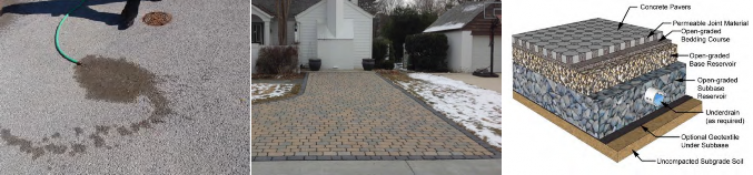
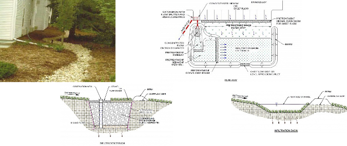
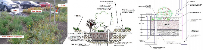
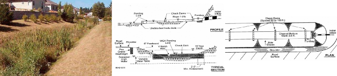
Table 2. Description of Chesapeake Bay Approved Urban Stormwater Best Management Practices. Practice Type: Environmental Site Design (ESD); Runoff Reduction (RR); Stormwater Treatment (ST); Downstream Restoration (DR); Usually Proprietary (UP); Often Proprietary (OP)
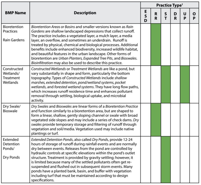
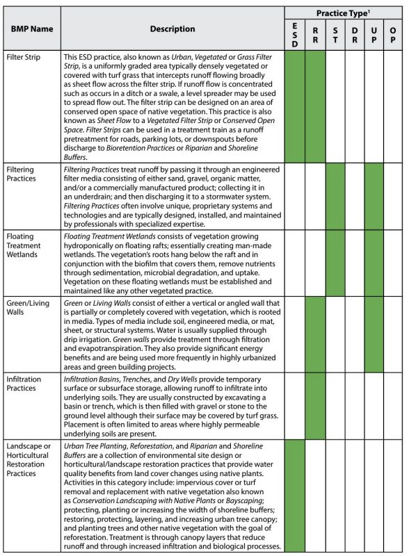
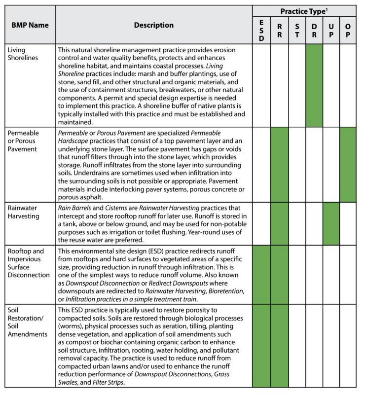
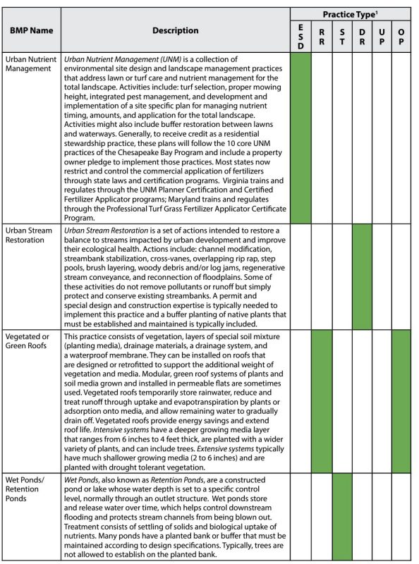
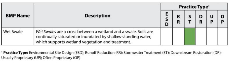
Table 3. Images of Chesapeake Bay Approved Urban Stormwater Best Management Practices.
Landscape or Horticultural Restoration Practices
Rooftop and Impervious Surface Disconnection
Soil Restoration/Soil Amendments
Urban Nutrient Management – 10 Core Practices
1. Maintain dense cover of grass or conservation landscaping; avoid bare soils
2. Reduce or Eliminate Fertilizer
3. Do not apply fertilizers before spring green up or after grass is dormant.
4. Maximize use of slow release Nitrogen fertilizer.
5. Immediately sweep off any fertilizer that lands on paved surfaces.
6. Never apply fertilizer within 15 to 20 feet of any water feature – manage as grass, meadow or forest buffer.
7. Keep clippings and mulched leaves on lawn and out of streets and storm drains.
8. Set mower height at 3 inches or higher.
9. Use other practices to increase the porosity and infiltration capability of lawn to treat stormwater.
10. Consult with a local extension service office or lawn care company to get best advice on how to have a Bay-friendly lawn, which might involve a soil test analysis.
Rainwater Harvesting – Cistern and Rain Barrels
Filter Strip
Vegetated/Green Roof
Permeable or Porous Pavement
Infiltration Practices
Bioretention
Wet Swale
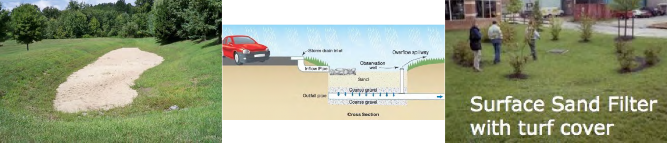
Filtering Practices
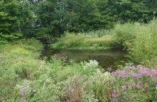
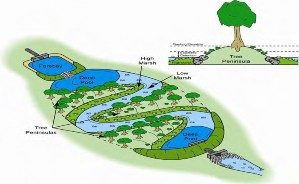
Constructed/Treatment Wetlands
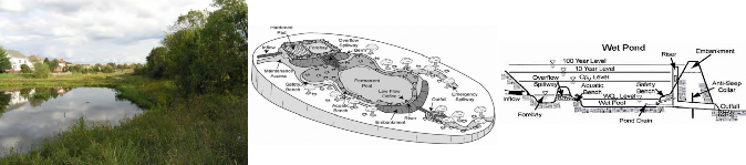
Wet/Retention Ponds
Extended Detention/Dry Ponds
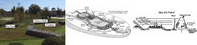
Urban Stream Restoration
Green/Living Walls
Living Shorelines
Floating Treatment Wetlands


EEOE Statement:
The University of Maryland, College of Agriculture and Natural Resources programs are open to all and will not discriminate against anyone because of race, age, sex, color, sexual orientation, physical or mental disability, religion, ancestry, or national origin, marital status, genetic information, or political affiliation, or gender identity and expression.
Virginia Cooperative Extension materials are available for public use, reprint, or citation without further permission, provided the use includes credit to the author and to Virginia Cooperative Extension, Virginia Tech, and Virginia State University.
Virginia Cooperative Extension is a partnership of Virginia Tech, Virginia State University, the U.S. Department of Agriculture (USDA), and local governments, and is an equal opportunity employer. For the full non-discrimination statement, please visit ext.vt.edu/accessibility.
Publication Date
December 8, 2020
